Overview Bridalveil Creek Campground is closed for the 2025 season.
Sites110all reservable
Elev.7,001ft
Comf.Jun-Sep4 months
Max rig35 ft1 pull-thru
Electricnonesites
From Fresno1h52real road time
The honest read
Synthesized from RIDB · Open-Meteo OSM · OSRM Updated 2026-05-27
At 7,001 ft, Bridalveil Creek Campground has a 4-month comfortable window (Jun-Sep). Winter nights average around 18°F, so the shoulder seasons turn cold fast. All 110 sites are reservable in advance, so plan ahead. Popular weekends book out. Of the sites, 1 pull-through, and the longest takes a 35-ft rig. Within about 4 miles: 1 named hiking route, 10 peaks.
What campers say
SYNTHESIZED · RICH SIGNAL
Vibe
01 / 06
Quieter and more wooded than valley campgrounds, fewer big RVs.
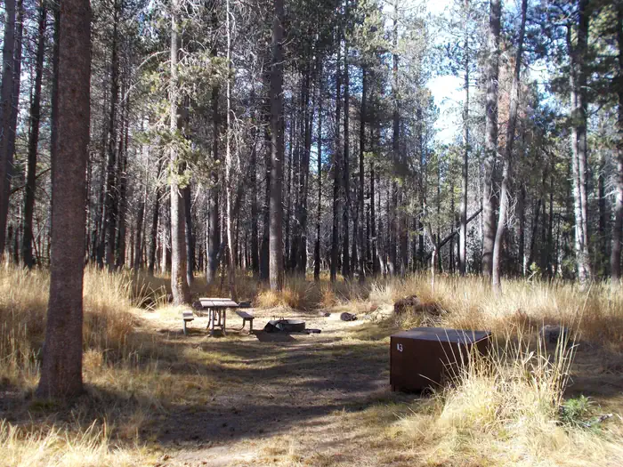
Campers consistently describe a forested feel under red fir and lodgepole pine with real spacing between sites. The lack of hookups keeps large rigs away, so the overall mood is calmer than Upper Pines or North Pines.
Booking
02 / 06
Reservation only, sells out in minutes when window opens.
Sites are released five months ahead on Recreation.gov at 7am PT on the 15th of each month and typically book out almost immediately. Campers recommend being logged in before the drop and watching cancellations daily as a backup.
Weather
03 / 06
Cold nights at 7,200 ft even when the valley is over 100.
Multiple trip reports note summer lows in the 40s and occasional 30s, with daytime highs 20 to 30 degrees cooler than the valley floor. Bring a real sleeping bag and layers even in July and August.
Sites
04 / 06
More space and privacy than other Yosemite campgrounds.
Reviewers across The Dyrt and TripAdvisor agree sites feel semi-secluded with trees and granite boulders between them. Bear lockers are present at every site but run shallow, around 18 inches tall, so taller coolers will not fit.
Access
05 / 06
Roughly 45 minutes to the valley on winding Glacier Point Road.
The campground sits nine miles up Glacier Point Road and about 26 miles from the valley floor, so most campers plan full-day trips rather than quick runs in and out. One reviewer called the drive white-knuckle, though most describe it as scenic and manageable.
Trails & access
06 / 06
Strong base for Glacier Point, Sentinel Dome, and Taft Point.
Campers repeatedly cite the short drive to the Glacier Point trailheads as the main reason to book here. Several recommend leaving before dawn in peak season to get parking at Sentinel Dome and Taft Point.
Synthesized from public trip reports and forum discussion, summarized in our words and never quoted. This is durable sentiment, not a live feed.
The campground at a glance
01 · CHARACTER
Reads strongest on reservability and shade. Softest on roomy sites.
Six axes, each scored relative to every other federal campground in the region: quiet (miles to a major road), cool (elevation), roomy (average site spacing), shade, RV-fit (longest rig), and how reservable it is. All six come from data, nothing hand-tuned.
When to go
02 · CLIMATE
avg highavg lowfrost-freedriest · Jul
Jun-Sep
Comfortable window: nights stay above 35°F, days below 90°F.
94%
Of summer weekend-days are dry.
Jun 15
Last spring frost; first fall frost Sep 24.
48°F
Average July low. Bring a fleece.
Getting there
03 · ACCESS
01
Fresno
84 mi
1h52
02
Sacramento
156 mi
3h28
03
San Francisco
199 mi
4h25
04
Los Angeles
339 mi
7h32
05
San Diego
480 mi
10h40
By drive time
Routed road time (OSRM). Nearest major highway 6.3 mi away.
We synthesize public data layers: RIDB and Recreation.gov facility and site records, Open-Meteo climate normals, OpenStreetMap roads, trails, and water, OSRM drive times, and USGS elevation. We take no bookings, no ads, and no paid placements. Independence is the entire point.