Overview Buckboard Crossing Campground is located on the far northwest shore of Flaming Gorge Reservoir at an elevation of 6,100 feet.
Sites5939 reservable
Elev.6,109ft
Comf.May-Oct6 months
Max rig45 ft6 pull-thru
Electric88×50-amp
From Jackson4h25real road time
The honest read
Synthesized from RIDB · Open-Meteo OSM · OSRM Updated 2026-05-27
At 6,109 ft, Buckboard Crossing has a 6-month comfortable window (May-Oct). Winter nights average around 12°F, so the shoulder seasons turn cold fast. 59 sites total: 39 reservable and 20 first-come, first-served. Of the sites, 6 pull-through, 8 with 50-amp, and the longest takes a 45-ft rig. Within about 4 miles: lake or river access.
What campers say
SYNTHESIZED · MODERATE SIGNAL
Vibe
01 / 06
High desert open camp next to the reservoir, not a forested escape.
Campers describe sagebrush flats at around 6,100 feet with scattered trees and big sky views. Several reviews compare the layout to a parking lot and warn anyone expecting pines to look elsewhere on the Gorge.
Weather
02 / 06
Daytime wind and full sun are the default, evenings usually calm down.
Multiple reports mention wind blowing most of the day before dropping off around sunset, plus harsh midday sun with very little natural shade. Bring sun cover and stake everything down.
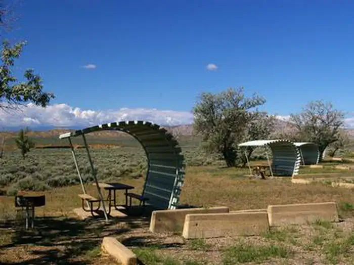
Sites
03 / 06
Loop A has electric and pull-throughs, Loop B is standard with a few elevated view sites.
Loop A handles larger rigs and has hookups, while Loop B is tent and dry sites with a handful (around 32 to 33) sitting higher with reservoir views. Pads are wide gravel and generally level, though some are short and weeds have crept in.
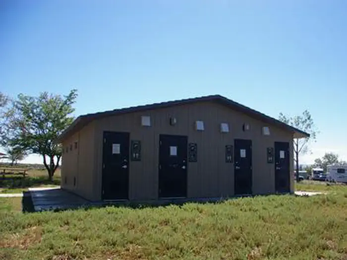
Facilities
04 / 06
Showers and flush toilets are clean, dump station has been unreliable.
Bathhouses get regular praise for hot water, pressure, and daily cleaning, with showers locking around 9 PM. The dump station has been reported inoperable in recent seasons, so plan to dump in Green River if needed.
Water
05 / 06
Marina, ramp, and fish cleaning station are right next door.
Buckboard Marina sits adjacent with boat rentals, fuel, slips, bait, and a small store, and the area is a known lake trout and kokanee zone. Expect motorboat and ramp traffic close to camp as the tradeoff for that access.
Access
06 / 06
Paved 25 miles south of Green River on WY 530, then two miles in on FR 009.
The drive from I-80 is straightforward on pavement with no rough approach, but cell service is patchy: AT&T works at some sites, Verizon and T-Mobile are mostly dead. Plan on being offline.
Synthesized from public trip reports and forum discussion, summarized in our words and never quoted. This is durable sentiment, not a live feed.
The campground at a glance
01 · CHARACTER
Reads strongest on shade and reservability. Softest on roomy sites.
Six axes, each scored relative to every other federal campground in the region: quiet (miles to a major road), cool (elevation), roomy (average site spacing), shade, RV-fit (longest rig), and how reservable it is. All six come from data, nothing hand-tuned.
When to go
02 · CLIMATE
avg highavg lowfrost-freedriest · Jul
May-Oct
Comfortable window: nights stay above 35°F, days below 90°F.
96%
Of summer weekend-days are dry.
May 6
Last spring frost; first fall frost Oct 8.
62°F
Average July low. Bring a fleece.
Getting there
03 · ACCESS
01
Jackson
215 mi
4h25
02
Casper
271 mi
5h09
03
Cheyenne
297 mi
5h13
By drive time
Routed road time (OSRM). Nearest major highway 1.2 mi away.
We synthesize public data layers: RIDB and Recreation.gov facility and site records, Open-Meteo climate normals, OpenStreetMap roads, trails, and water, OSRM drive times, and USGS elevation. We take no bookings, no ads, and no paid placements. Independence is the entire point.