Overview Fish Creek Campground is the second largest campground in Glacier National Park.
Sites189170 reservable
Elev.3,261ft
Comf.May-Sep5 months
Max rig35 ft163 pull-thru
Electricnonesites
From Missoula3h12real road time
The honest read
Synthesized from RIDB · Open-Meteo OSM · OSRM Updated 2026-05-27
At 3,261 ft, Fish Creek Campground has a 5-month comfortable window (May-Sep). Winter nights average around 19°F, so the shoulder seasons turn cold fast. 189 sites total: 170 reservable and 19 first-come, first-served. Of the sites, 163 pull-through, 5 walk-in, and the longest takes a 35-ft rig. Within about 4 miles: 1 peak, lake or river access.
What campers say
SYNTHESIZED · RICH SIGNAL
Booking
01 / 06
Six-month window fills fast; cancellations and waitlist are the realistic way in.
Most sites release on a six-month rolling window and book within minutes of opening for peak summer dates. Campers who miss the initial drop report success watching for cancellations and signing up for the waitlist rather than expecting a clean reservation.
Sites
02 / 06
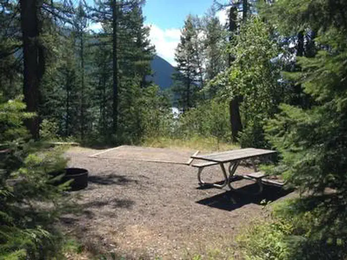
Loop choice matters more than site number; levelness and size vary a lot.
Loop C sits closest to Lake McDonald, has the most tree cover, and bans generators, which campers consistently flag as the quietest option. Loop B has a row above Fish Creek with audible water, Loop A holds the only showers, and several reviewers warn that individual sites range from tight and sloped to spacious, so checking site photos before booking is standard advice.
Water
03 / 06
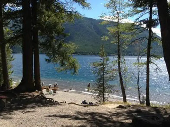
Lake McDonald is a short walk from many sites.
Multiple loops have footpaths reaching the lake in a few minutes, and a handful of sites sit close enough for direct shoreline access. Campers use it for swimming, paddling, and evening light on the water.
Facilities
04 / 06
Flush toilets are clean; showers are the weak point.
Bathrooms across loops get steady praise for cleanliness and working flush toilets. The shower situation draws complaints: a small number of stalls clustered in Loop A, frequent cold water by evening, and a walk or short drive from the other loops.
Wildlife & sky
05 / 06
Active bear country with strict food storage enforcement.
Both grizzly and black bears move through the area and rangers enforce food storage rules at every site, with hard-sided vehicles or bear lockers required for anything with a scent. Deer sightings in the campground are routine; actual bear encounters at sites are uncommon but the protocols are taken seriously.
Access
06 / 06
West-side base camp with no guaranteed drive past Apgar in past years.
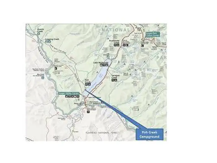
Fish Creek puts campers minutes from Apgar Village and the foot of Going-to-the-Sun Road, which is the main draw. In recent seasons a camping reservation did not include a vehicle reservation for the Sun Road corridor; for 2026 the park has suspended that timed-entry system, though rolling closures when areas fill remain possible.
Synthesized from public trip reports and forum discussion, summarized in our words and never quoted. This is durable sentiment, not a live feed.
The campground at a glance
01 · CHARACTER
Reads strongest on shade and reservability. Softest on roomy sites.
Six axes, each scored relative to every other federal campground in the region: quiet (miles to a major road), cool (elevation), roomy (average site spacing), shade, RV-fit (longest rig), and how reservable it is. All six come from data, nothing hand-tuned.
When to go
02 · CLIMATE
avg highavg lowfrost-freedriest · Jul
May-Sep
Comfortable window: nights stay above 35°F, days below 90°F.
82%
Of summer weekend-days are dry.
May 14
Last spring frost; first fall frost Oct 14.
52°F
Average July low. Bring a fleece.
Getting there
03 · ACCESS
01
Missoula
141 mi
3h12
02
Helena
218 mi
4h16
03
Bozeman
334 mi
6h07
04
Billings
416 mi
7h55
By drive time
Routed road time (OSRM). Nearest major highway 3.5 mi away.
Loop C- No Generator Loop · good location · pull-through · shaded.
To neighbor
64 ft
Location
Good
Max rig
24 ft
Type
Pull-thru
What's within four miles
05 · TRAILS · PEAKS · WATER
Trails & Peaks
Trail segments
105
Peaks
1
Viewpoints
1
Water & Access
Lake / river access
yes
To nearest major road
3.5 mi
Method
We synthesize public data layers: RIDB and Recreation.gov facility and site records, Open-Meteo climate normals, OpenStreetMap roads, trails, and water, OSRM drive times, and USGS elevation. We take no bookings, no ads, and no paid placements. Independence is the entire point.