Overview Stevens Creek Campground lies on the north shore at the eastern end of Blue Mesa Reservoir.
Sites55first-come
Elev.7,592ft
Comf.May-Sep5 months
Max rig40 ft
Electricnonesites
From Grand Junction2h38real road time
The honest read
Synthesized from RIDB · Open-Meteo OSM · OSRM Updated 2026-05-27
At 7,592 ft, Stevens Creek Campground has a 5-month comfortable window (May-Sep). Winter nights average around 10°F, so the shoulder seasons turn cold fast. All 55 sites are first-come, first-served. No reservations, so arrive early. Within about 4 miles: 1 peak, lake or river access.
What campers say
SYNTHESIZED · MODERATE SIGNAL
Views
01 / 05
Open reservoir panoramas in every direction, especially at sunset.
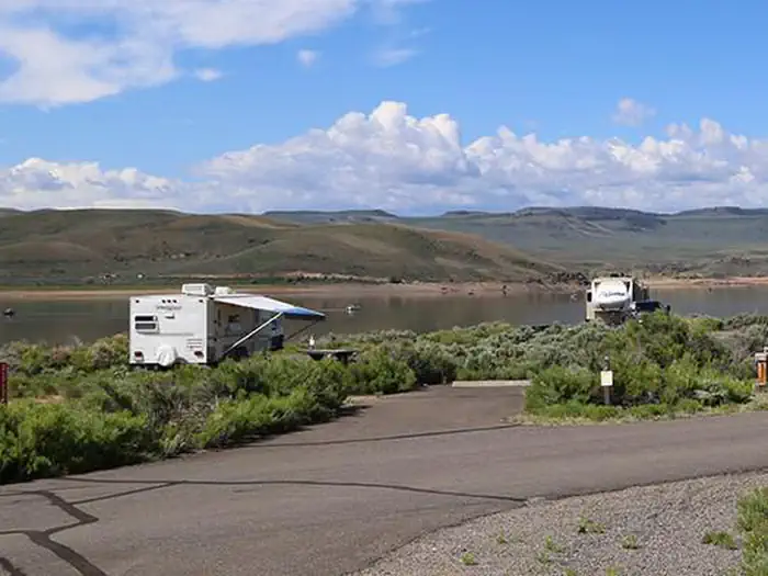
Sites sit right on Blue Mesa's Iola Basin with unobstructed water and ridgeline views, and the lower-numbered sites (1, 2, 4, 6, 7, 9) put you closest to the shoreline. Sunset is the payoff after a hot, exposed afternoon.
Weather
02 / 05
Relentless afternoon wind and zero shade define the daytime experience.
The treeless sagebrush flat at 7,540 feet offers no windbreak, and reviewers consistently describe whitecaps on the lake and tents that have to be held down. Bring a sturdy shade structure and heavy stakes, not a pop-up canopy.
Water
03 / 05
Strong boater and angler base, with kokanee and lake trout the draw.
Blue Mesa is one of Colorado's top kokanee fisheries and holds the state lake trout record, with peak fishing in spring and fall. Note that the Stevens Creek boat ramp and inspection station have been reported closed recently, so confirm status before towing.
Sites
04 / 05
Level, reasonably spaced sites, but exposed and RV-leaning.
Loop A's 20 reservable sites are considered premium and book ahead, while remaining sites are first-come. The open layout favors RVs and vans; tent campers report feeling cramped and unsheltered against the wind.
Facilities
05 / 05
No hookups, clean vault toilets, self-pay scan-and-pay system.
Expect potable water late May through mid-September, vault restrooms that reviewers call clean, and no electric, water, or sewer at sites. Cell coverage is patchy: AT&T users report usable signal, Verizon and T-Mobile users often report little to none.
Synthesized from public trip reports and forum discussion, summarized in our words and never quoted. This is durable sentiment, not a live feed.
The campground at a glance
01 · CHARACTER
Reads strongest on cool nights and quiet. Softest on reservability.
Six axes, each scored relative to every other federal campground in the region: quiet (miles to a major road), cool (elevation), roomy (average site spacing), shade, RV-fit (longest rig), and how reservable it is. All six come from data, nothing hand-tuned.
When to go
02 · CLIMATE
avg highavg lowfrost-freedriest · Jun
May-Sep
Comfortable window: nights stay above 35°F, days below 90°F.
86%
Of summer weekend-days are dry.
May 13
Last spring frost; first fall frost Oct 5.
55°F
Average July low. Bring a fleece.
Getting there
03 · ACCESS
01
Grand Junction
113 mi
2h38
02
Colorado Springs
184 mi
4h07
03
Denver
210 mi
4h46
04
Fort Collins
272 mi
5h52
By drive time
Routed road time (OSRM). Nearest major highway 0.3 mi away.
We synthesize public data layers: RIDB and Recreation.gov facility and site records, Open-Meteo climate normals, OpenStreetMap roads, trails, and water, OSRM drive times, and USGS elevation. We take no bookings, no ads, and no paid placements. Independence is the entire point.