Overview Trillium Lake Campground is a beautiful and popular campground not far from the quaint town of Government Camp.
Sites6550 reservable
Elev.3,645ft
Comf.May-Oct6 months
Max rig95 ft7 pull-thru
Electricnonesites
From Portland1h36real road time
The honest read
Synthesized from RIDB · Open-Meteo OSM · OSRM Updated 2026-05-27
At 3,645 ft, Trillium has a 6-month comfortable window (May-Oct). Winter nights average around 29°F, so the shoulder seasons turn cold fast. 65 sites total: 50 reservable and 15 first-come, first-served. Of the sites, 7 pull-through, 10 walk-in, and the longest takes a 95-ft rig. Within about 4 miles: 6 named hiking routes, 9 peaks, lake or river access.
What campers say
SYNTHESIZED · RICH SIGNAL
Views
01 / 06
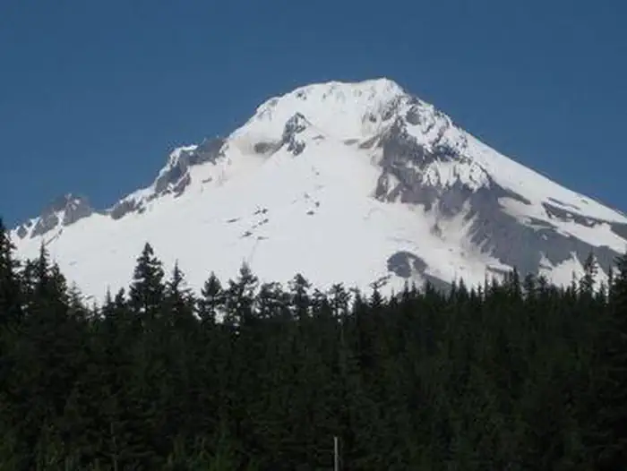
The Mt Hood reflection is the headliner and it earns the reputation.
Multiple sources call out the postcard reflection of Mt Hood off a glassy lake, best at dawn from the south end and the dam. Cloud cover can hide the mountain for an entire stay, so reviewers say to track the forecast before locking in dates.
Booking
02 / 06
Summer weekends vanish minutes after the 6-month window opens.
Reviewers consistently say to book on Recreation.gov right at the 180-day mark for any Friday or Saturday in July or August. A handful of first-come walk-in sites exist, but campers report needing to roll in Sunday through Wednesday before 8am to have a real shot.
Sites
03 / 06
Lakeside loops draw the crowd, interior sites trade view for privacy.
Reports point to shoreline sites in the low single digits and upper 30s to low 40s for the iconic view, while higher-numbered interior sites get more tree cover and quiet. RVs over about 30 feet should check length limits, since several reviewers describe tight access roads and narrow pull-ins.
Water
04 / 06
Shallow, sandy, swimmable, and warmer than most Mt Hood lakes.
The 63-acre lake tops out around 20 feet deep with a sandy bottom and gradual entry, which campers say makes it usable for swimming and wading by mid summer. Non-motorized only, so kayaks, canoes, and paddleboards dominate the water and the surface stays calm.
Wildlife & sky
05 / 06
Mosquitoes are a real factor from late spring through midsummer.
Multiple guides and trip reports flag heavy mosquito pressure around the lake and wooded loops, especially at dusk. Reviewers recommend packing repellent, long sleeves, and a citronella option rather than relying on a quick coil.
Facilities
06 / 06
Vault toilets, potable water, no showers or hookups.
Sites come with picnic tables, fire rings with grills, and paved parking, with vault toilets and spigots spread through the loops. A few reviewers note bathroom upkeep varies by week, and there is an accessible fishing pier and small non-motorized boat ramp inside the campground.
Synthesized from public trip reports and forum discussion, summarized in our words and never quoted. This is durable sentiment, not a live feed.
The campground at a glance
01 · CHARACTER
Reads strongest on reservability and shade. Softest on roomy sites.
Six axes, each scored relative to every other federal campground in the region: quiet (miles to a major road), cool (elevation), roomy (average site spacing), shade, RV-fit (longest rig), and how reservable it is. All six come from data, nothing hand-tuned.
When to go
02 · CLIMATE
avg highavg lowfrost-freedriest · Jul
May-Oct
Comfortable window: nights stay above 35°F, days below 90°F.
84%
Of summer weekend-days are dry.
May 11
Last spring frost; first fall frost Oct 15.
52°F
Average July low. Bring a fleece.
Getting there
03 · ACCESS
01
Portland
61 mi
1h36
02
Bend
106 mi
2h37
03
Eugene
158 mi
3h31
04
Medford
278 mi
6h32
By drive time
Routed road time (OSRM). Nearest major highway 0.8 mi away.
We synthesize public data layers: RIDB and Recreation.gov facility and site records, Open-Meteo climate normals, OpenStreetMap roads, trails, and water, OSRM drive times, and USGS elevation. We take no bookings, no ads, and no paid placements. Independence is the entire point.